Hiking in the south of France offers the ideal opportunity to explore a diverse and beautiful landscape whether you are a casual stroller or an ardent hiker. From coastal promenades to mimosa-covered hills, Mediterranean oak forests to alpine valleys, the French Riviera really is a walker’s paradise.
Bespoke Yacht Charter has curated a list of some of our favourite regional walks and hikes, with many of our suggestions located not far from the region’s marinas and ports meaning an onshore hiking excursion is viable for our French Riviera yacht charter guests – come with us to discover the cliff top trails above the calanques near Marseille to the rocky paths dissecting the Parc National du Mercantour.
1. The Calanques
Often called Mediterranean fjords, calanques were not formed from glaciers like their Scandinavian counterparts but were created by rivers coursing through a fault line in the mountain chain. When the sea level rose, the canyons were partly flooded, leaving coves of narrow underwater valleys.
The most popular calanques are situated between Marseille and Cassis, but calanques are found all the way to Toulon. The calanques in the area between Marseille and La Ciotat as well as the offshore islands of Frioul and Riou, were declared a National Park in 2012.
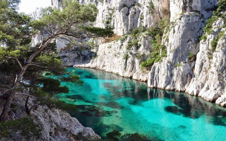
Some calanques you can explore are Port Pin, en Vau, Sormiou, Sugiton, Morgiou, Niolon, Figuerolles, and Port d’Alon with typical Mediterranean flora growing freely along the trails such as pine trees, olive trees, wild flowers in spring, and wild herbs such as thyme and rosemary. There is an interesting range of wildlife to be found as well including seabirds, rabbits and reptiles such as the Montpellier snake and the ocellated lizard, the largest lizard in Europe which loves the sunny rocky paths leading to the calanques.
Because of high temperatures and winds in warmer months, an important tip to know is access to the calanques trails is restricted by law between 01 June and 30 September because of high fire risks. During this period there are three risk levels: Orange (access authorised), Red (access authorised between 6am and 11am) and Black (access prohibited).
The level varies according to weather conditions and is set daily at 6pm for the following day so you should check prior to embarking on any of the trails. You can find out the risk level via:
- The official helpline telephone: +33 08 11 20 13 13 (in English and French)
- Online (in French only) at www.calanques13.com/acces-massifs-forestiers.html
- The smartphone application ‘MyProvence Envie de balade’ from the iTunes App Store or Google Play (in French only).
For maps to The Calanques, the Tourist Office of Cassis has good information and directions for walkers and hikers.
2. Cap Dramont
The Corniche de l’Estérel, also known as the Corniche d’Or or ‘Golden Coast’ is not to be missed and offers dramatic views of both the red rhyolite ranges of the Estérel and the shimmering blue sea.
The ‘Sentier du Cap Dramont’ (Cap Dramont walk) near Agay and Saint-Raphaël is a pleasant coastal walk of less than 2 hours duration that weaves through pine forests leading to sandy and pebble-strewn beaches tucked in between the red rocks.

The headland is a protected area with historical significance as one of the landing sites for the Allies during WWII at Plage de Débarquement. Start the walk at the car park (there is a landing craft and memorial stone at the car park) and follow the waymarked path in yellow. Highlights of the walk include a short detour to the perimeter of the signalling station (Semaphore) for views of the Gulf of Fréjus and the Ile d’Or with its small tower, which is said to have inspired Belgian cartoonist Hergé for his comic ‘Tintin and the Black Island’.
The Tourist Office in Saint Raphael has a leaflet for the Cap Dramont walk, and other popular walks and hikes in the area to Cap Roux and Pic de l’Ours via the Vallon du Mal Infernet.
3. Circuit de l’Aiguille
The resort of Théoule-sur-Mer is a lovely coastal town and is known as ‘La Ville d’Ecriture’, whereby it hosts an annual Fête de l’Écriture in June with workshops, competitions and exhibitions of calligraphy, Braille and paintings.
Situated on a stunning coastline, water sports are popular in Théoule-sur-Mer where you can try your hand at sailing, kayaking or snorkeling (between mid-June and mid-September you can borrow waterproof maps from the Tourist Office in Théoule that detail a snorkeling trail off the main beach).

For yacht charter guests in the area, we recommend a spot of onshore pampering at the Tiara Miramar Beach Hotel and Spa that has a wellness centre and the perfectly positioned Moya restaurant and beach bar with views that encourage a sunset drink or two.
From the main beach in Théoule-sur-Mer, the Circuit de l’Aiguille walk is an easy hike along a path that follows the landscape of solidified lava under the shade of eucalyptus, pine and oak trees.
Start at the Théoule beach and follow the pathway to plage Gardanne before crossing the road and venturing up along the forested dirt track to the summit for panoramic views over the Gulf of La Napoule.
4. Château de La Napoule and surrounds
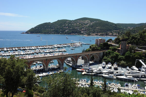
Mandelieu-La Napoule is located just 10 kilometres from Cannes, a major charter destination where year round events at the Palais des Congrès et Festivals keep Bespoke Yacht Charter busy with charter bookings.
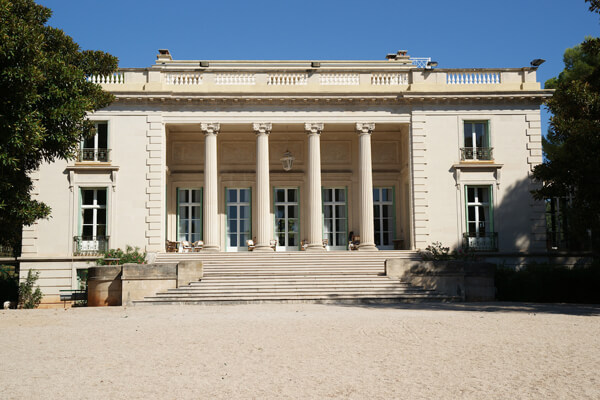
Back in Mandelieu, Bespoke Yacht Charter recommends lunch at Michelin-starred L’Oasis followed by a lovely walk that takes in the surrounds of the Château de La Napoule, a restored medieval castle registered as a monument historique with pleasant gardens that have received the designation jardin remarkable by the French Ministry of Culture. The Château is a legacy to Americans Marie and Henry Clews and has permanent collections of art and sculptures as well as temporary exhibitions.
After passing under the Château’s archways on the seafront, a coastal path continues to the small Port de la Rague before heading uphill past the Château d’Agecroft (now functioning as a holiday village).
A small detour takes walkers up to the summit of San Peyre through olive trees where you can enjoy views over the bay of Cannes, Château de La Napoule and Théoule-sur-Mer.
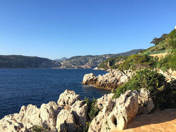
5. Cap d’Antibes
A great walk on the Cap d’Antibes peninsula, the Sentier du Littoral (also known as the Sentier de Tire-Poil) coastal path starts at Plage Garoupe and follows a loop past rocky coves and magnificent real estate ending at a stone grotto looking across to the small Pointe de I’llette lighthouse on the far side of the luxuriously-named Baie des Milliardaires.
Exercise caution with swimming as this coastline is notoriously volatile; in times of high winds or particularly stormy weather the trail is closed so heed the warnings that are placed at the entry points.
If you can, stop into the Villa Eilenroc that the trail passes. Designed by Charles Garnier, the architect who created both the Paris and Monte-Carlo Opéra houses, this neoclassical mansion was built in the 1860’s by the former Governor of the Dutch East Indies, Hugh Hope London, who christened the Villa ’Eilenroc’ – an anagram of Cornelie, his first wife’s name.
Today, you can visit the villa and its renowned rose gardens, we recommend you check opening hours first prior to coming as entrance is selected days of the week only and sometimes the Villa is closed to the public for gala events.
6. Balcons du Loup
Starting one kilometre after the Bramafan bridge in the Gorges du Loup, hikers can follow the maintenance road beside the Canal du Foulon (a wide metal pipe that draws water from the Loup valley).
The pipe cuts around 20 tunnels in the limestone rock and the trail uncovers a diverse variety of flora and fauna such as wild flowers, bats and butterflies. Panoramic openings in the rock allow glimpses of the Courmes waterfall and into the valley.
The Canal was built in the early 20th century due to a population increase in Grasse resulting in a need for quality water to support the perfume industry. The metal pipe was installed in the 1950’s and winds 22 kilometres along the Loup Valley.

The trail diverts towards the perched village of Gourdon before continuing by descent on the chemin du Paradis.
The walk finishes at Pont du Loup under the ruins of a train viaduct that was destroyed in WWII.
This walk is not advisable for people with vertigo due to the overhanging nature of some of the balconies; we also recommend a headlamp or torch for the tunnels and suitable footwear as often the tunnels have puddles.
For directions for this walk, refer to the Walk Number 36 in the ‘Pays Cotier’ guide book at the end of this article.
Please note: The description above is the walk in reverse for the section from Bramafan to Pont du Loup via Gourdon so as to allow for a downhill descent on the chemin du Paradis.
7. Saint Jean Cap Ferrat
A spectacular coastal circuit that takes in the beauty of the Saint Jean Cap Ferrat peninsula and views across the water to Villefranche-sur-Mer and Beaulieu-sur-Mer.
There are multiple options for routings, but we suggest starting at the port of Saint Jean Cap Ferrat, enjoying a leisurely lunch at Paloma Beach, looping around the Sainte Hospice isthmus before continuing on the coastal pathway to Plage Passable.
Walkers can also add on a visit to the beautiful Villa Ephrussi de Rothschild, or a side walk along the Promenade Maurice Rouvier to nearby Beaulieu-sur-Mer.

For directions for this walk, you can combine routings from Walk Numbers 49, 50 and 51 in the ‘Pays Cotier’ guide book.
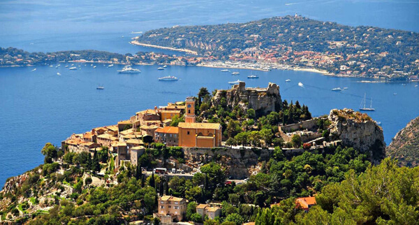
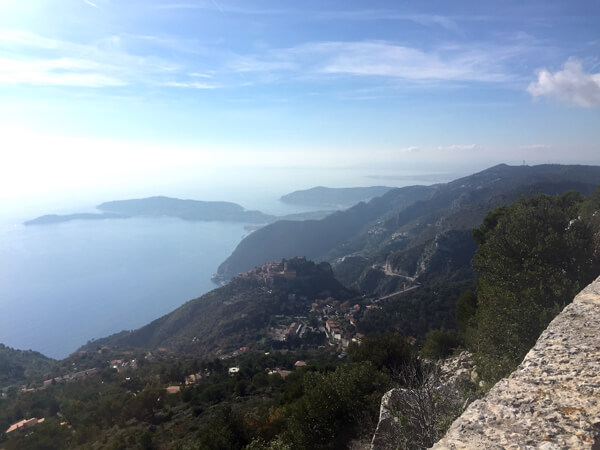
8. Sentier Nietzsche
Starting at Eze-sur-Mer, the Sentier Nietzsche (chemin de Nietzsche) winds uphill from opposite the train station to the eagles nest village of Eze where the trail finishes near the spectacular Château de la Chèvre d’Or.
Best avoided on hot days, the path is named after German philosopher Friedrich Nietzsche who found inspiration on the steep hillside with the Mediterranean behind him and the village above him to write the third part of the book Thus Spoke Zarathustra.
“Everything dies, everything blossoms again, the cycle of life continues eternally” he wrote, which seems fitting on a pathway that blends the changes of seasons evident in gnarled olive trees, wild herbs and sun scorched cypress trees.
The ascent takes around 1.5 – 2 hours; the descent about 45 minutes – 1 hour if you are in good fitness. The path is rocky, uneven and steep in parts so sturdy footwear is recommended.
For directions for this walk, you can simplify the directions from Walk Number 19 (Circuit du Mont Bastide) in the ‘Pays Cotier’ guide book.
9. Fort de la Revère
Part of the Parc du Grande Corniche, the Fort de la Revère walk encompasses a historical area that was occupied by Celtic-Ligurian tribes in Roman times. You can’t access the derelict military Fort, however the setting is exceptional.
With a dominant position, the walk offers breath taking vistas to Italy, of Eze, and as far reaching as Saint Tropez and Corsica on clear days. For those interested in botany, there are botanical and geological sign-posts that provide information (in French) of the park’s flora and landscape with plenty of picnic tables to stop and enjoy the views.

A jogging trail was created on the nearby Plateau de la Justice, and from late August to early November, migratory bird-watching facilities are provided here for the public where you may catch a glimpse of a swooping bird of prey.
If you are in the area in the evenings, a visit to the Astrorama allows you into a world of astronomy with telescope evenings and interactive workshops about everything space-related.
For directions for this walk, refer to Walk Number 15 (Fort de la Revère) in the ‘Pays Cotier’ guide book.
10. Roquebrune-Cap-Martin to Monaco
Starting at the Gare de Carnolès train station, this is another superb coastal walk with views of the mountain and sea on the Menton side, and the high-rises of Monaco on the other.
This walk passes private estates on Cap Martin, dips in and out of rocky coves fringed by parasol pines and maritime scrub and includes many steps for those looking for a leg workout. It is also important to mention that the path includes a couple of steel bridges cantilevered to the adjacent wall, they are not overhanging at a great height though for those inclined to vertigo they may seem hair-raising!

Better known as the ‘Promenade Le Corbusier’, the path was named after Swiss-born French architect Le Corbusier who built a holiday cabin off the pathway. There is also a memorial bust of him along the pathway.
If you want to visit Le Corbusier’s Cabanon, guided tours can be arranged through the Roquebrune-Cap-Martin Tourist Office. If you’re wondering why he created himself such a tiny retreat (15 msq), in true architect style it was designed using modulor principles, based on human proportions. The walls are the height of a six-foot man with one arm above his head, the basic modulor unit. The sides of the cabin are twice the length of a six-foot man.
Le Corbusier sadly drowned off the Cap Martin coast and is buried in the cemetery at Roquebrune.
For directions for this walk, it is from Walk Number 45 (Tour du Cap Martin) in the ‘Pays Cotier’ guide book.
11. Monaco to Cap d’Ail
Heading west from Fontvieille in Monaco, walkers pass Plage Marquet and join the paved Sentier Littoral pathway that leads to stunning Plage Mala at Cap d’Ail.

The walk passes immense Belle Epoque mansions and provides a nice pathway for a coastal walk, though be wary of joggers! This walk is not strenuous (excluding the remaining section near Plage Mala) and easy to tack onto a day excursion in Monaco.
The reward is a picturesque setting at Plage Mala, one of the French Riviera’s best beach clubs surrounded by limestone cliffs – we love lunch at Eden Plage Mala, reservations recommended especially in peak season.
For directions for this walk, it is from Walk Number 48 (Sentier du Cap d’Ail) in the ‘Pays Cotier’ guide book.
12. Mercantour National Park
Venturing one hour’s drive from Nice and up to the high country, you follow narrow vertiginous hair-pin roads that pass woods pierced by small villages clinging to rocky buttresses. As the roads climb in altitude, the population dwindles from the busy coastal towns and you start to see why this area is popular with hikers.
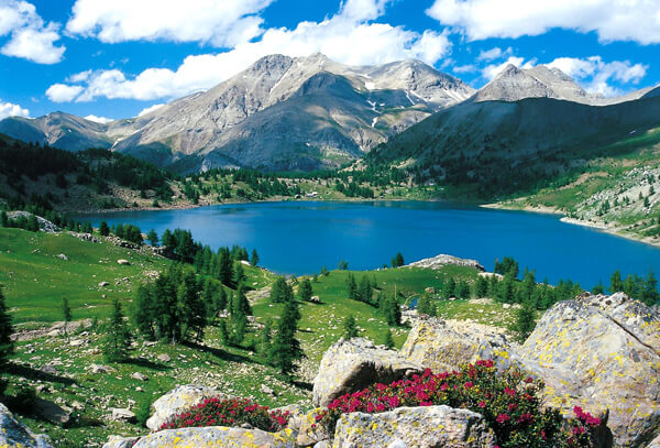
An area of exceptional beauty, the Parc National du Mercantour is home to alpine fauna and flora such as marmots, bouquetin/chamois (alpine goats), orange lillies, gentiane, edelweiss, wild flowers and plaintain.
The biggest attraction though is the Vallée des Merveilles, the ‘Valley of Marvels’ where at the foot of Mont Bégo are found signs of early human presence in some 40,000 rock carvings dating mostly around 3300 years BC.
Due to its proximity to Italy and a long history as the crest of the Salt Route and the hunting ground of Italian kings, don’t be surprised to find Italian culture seeping through the Mercantour villages. After a hike, buy some local honey, cow’s cheese, or olive oil and stop into a local restaurant for a grappa and pizza.

The most important visitor centres are at Saint-Martin-Vésubie, Saint-Etienne-de-Tinee, Barcelonnette, Péone and Tende. Tende also has the Musée des Merveilles with archaeological, ethnological and natural history collections for those not keen on hiking to experience the real thing.
There are many outstanding walks to do in this area with over 600 kilometres (347 miles) of hiking trails criss-crossing meadows, valleys and peaks.
We suggest doing a half-day’s walk from Larche to the Lac du Lauzanier (altitude 2284 metres), the easily manageable Vacherie Boréon walk from Le Boréon or for those with more time and fitness tackling one of the registered Grande Randonnée routes, GR5 or GR52.
Other top sights in or near the Mercantour:
- Lac Verte de Fontanalbe
- Lac des Mesches
- Lac de la Minière
- Lac Negre
- Villages of Venanson, Coaraze and Péone
- Alpha Wolf Park and Lac Boréon
- Chapelle Notre-Dame-des-Fontaines near La Brigue
Useful tips for walking and hiking on the French Riviera
The climate of the region can be harsh and hot everywhere in summer, and bitterly cold in the hinterland come autumn. Always be mindful of weather conditions which can change quickly. Dress appropriately with sturdy footwear and layers of clothing with consideration for sun and rain protection and take plenty of water and snacks. It’s advisable to carry a map, GPS (if on remote trails) and tell someone your intended plans.
Particular caution should be applied on alpine trails. Always check weather conditions, take appropriate gear/clothing/footwear, and heed avalanche warnings or advice of trail closures. There are plenty of experienced guides who can accompany you on walks and hikes to suit your ability. Snow can reach far down into the valleys of the French Riviera so be prepared.
Be aware that the regional hunting season opens in mid-September and runs until the end of February so stick to marked walking trails and wear bright clothing if you join remote trails.
Recommended Resources
As well as the walks above, the Conseil Général des Alpes Maritimes has free walking and hiking guide books called ‘Guide Randoxygene’ available online or at any regional Tourism Office with over 100 walks of different grades.
Pays Cotier: These walks are coastal or within less than 30 minutes from the coast and generally of an easy grade.
Moyens Pays: These walks are slightly inland with many incorporating village routes and hinterland forests; grades range from easy to high level of fitness. They are ideal in autumn or spring when the weather isn’t too hot.
Haut Pays: These walks are for medium to high fitness and can vary in length from a few hours to a few days in duration. They take in the magnificent scenery of the Vallée des Merveilles, Haute Vésubie, Haute Roya, and Mercantour with mountain landscapes, forests and alpine lakes.
Aside from our 12 Must-Do walks, we also suggest:
- Lacs de Pral (Walk Number 42 in Haut Pays)
- Circuit des Forts (53 in Haut Pays):
- Circuit des Fontanable (54 in Haut Pays)
- The Sentier Botanique nature trail from Sospel to Olivetta
This article was written by Rebecca Whitlocke, who with over 10 years travel industry experience loves to share ‘must-do’ destination tips and hidden spots to discover in France and beyond.
For further information on yacht charters in France, please contact:

